Friday, August 31, 2012

Banff National Park: Lake Louise: Fairview Mountain

Fairview Mountain (sometimes called Mount Fairview) is a mountain in Banff National Park near Lake Louise, Alberta. The mountain was named in 1894 by Walter Wilcox, which reflects the view from the top. An alternate name for the peak is Goat Mountain although it is rarely referred to as such.[1]
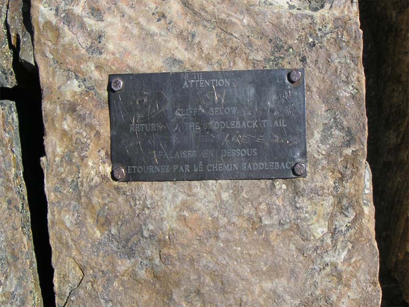
Fairview Mountain is a popular easy scramble in the Lake Louise area and can be combined with nearby Saddle Pass/Peak trail. For the modest effort expended it offers some of the best views of the area. While the mountain shows formidable cliff bands from the lake, a hiking trail ascends to a saddle where a footpath leads experienced hikers to the top. A plaque is embedded near the rock bands above the lake warning not to attempt a descent on this side — while the way is initially easy, rock bands quickly change it to a technical descent. Numerous rescues have been made to retrieve stranded hikers who disregarded the warning.
While the first recorded ascent took place in 1893, it is probable that the mountain was ascended earlier than that by an aboriginal explorer.

9000ft elevation - 10km hike


Lake Louise is a lake in AlbertaCanada. The glacial lake is located in Banff National Park, 5 km (3.1 mi) from the hamlet ofLake Louise and the Trans-Canada Highway.
Lake Louise is named after the Princess Louise Caroline Alberta (1848–1939),[1] the fourth daughter of Queen Victoria and the wife of the Marquess of Lorne, who was the Governor General of Canada from 1878 to 1883. The Stoney Natoka Indian name for the lake is "Lake of the Little Fishes".[2]
The emerald colour of the water comes from rock flour carried into the lake by melt-water from the glaciers that overlook the lake. The lake has a surface of 0.8 km2 (0.31 sq mi) and is drained through the 3 km long Louise Creek into the Bow River.
Fairmont's Chateau Lake Louise, one of Canada's grand railway hotels, is located on Lake Louise's eastern shore. It is a luxury resort hotel built in the early decades of the 20th century by the Canadian Pacific Railway.


http://www.banfflakelouise.com
http://en.wikipedia.org/wiki/Lake_Louise_(Alberta)
http://en.wikipedia.org/wiki/Fairview_Mountain_(Alberta)

Friday, August 24, 2012

Olympic National Park: High Divide Loop: Seven Lakes Basin

 U.S. President Theodore Roosevelt originally created Mount Olympus National Monument in 1909[3]and after Congress voted to authorize a re-designation to National Park status, President Franklin Roosevelt signed the legislation June 29, 1938. In 1976, Olympic National Park became an International Biosphere Reserve, and in 1981 it was designated a World Heritage Site. In 1988, Congress designated 95 percent of the park as the Olympic Wilderness.[4][5]


Glaciated Mtns: Within the center of Olympic National Park rise the Olympic Mountains whose sides and ridgelines are topped with massive, ancientglaciers. The mountains themselves are products of accretionary wedge uplifting related to the Juan De Fuca Plate subduction zone. The geologic composition is a curious mélange of basaltic and oceanic sedimentary rock. The western half of the range is dominated by the peak of Mount Olympus, which rises to 7,965 feet (2,428 m). Mount Olympus receives a large amount of snow, and consequently has the greatest glaciation of any non-volcanic peak in the contiguous United States outside of the North Cascades. It has several glaciers, the largest of which is the Hoh Glacier, nearly five kilometers in length. Looking to the east, the range becomes much drier due to the rain shadow of the western mountains. Here, there are numerous high peaks and craggy ridges. The tallest summit of this area is Mount Deception, at 7,788 feet (2,374 m).


Distance: Loop is 18.2 miles
Elevation change: 3050 feet gain


Ecology: Because the park sits on an isolated peninsula, with a high mountain range dividing it from the land to the south, it developed manyendemic plant and animal species (like the Olympic Marmot and Piper's bellflower). The southwestern coastline of the Olympic Peninsula is also the northernmost non-glaciated region on the Pacific coast of North America, with the result that - aided by the distance from peaks to the coast at the Last Glacial Maximum being about twice what it is today - it served as a refuge from which plants colonized glaciated regions to the north.
It also provides habitat for many species (like the Roosevelt elk) that are native only to the Pacific Northwest coast. Because of this importance, scientists have declared it to be a biological reserve, and study its unique species to better understand how plants and animals evolve.
The park contains an estimated 366,000 acres (572 sq mi; 1,480 km2) of old-growth forests


When settlers began to appear, extractive industry in the Pacific Northwest was on the rise, particularly in regards to the harvesting of timber, which began heavily in the late 19th and early 20th centuries. Public dissent against logging began to take hold in the 1920s, when people got their first glimpses of the clear-cut hillsides. This period saw an explosion of people's interest in the outdoors; with the growing use of the automobile, people took to touring previously remote places like the Olympic Peninsula.

illegal logging continued in the park, and political battles continue to this day over the incredibly valuable timber contained within its boundaries. Logging continues on the Olympic Peninsula, but not within the park. A book detailing the history of the fight for ONP's timber is Olympic Battleground: The Power Politics of Timber Preservation by Carsten Lien.


http://www.nps.gov/olym/planyourvisit/high-divide-loop.htm
http://en.wikipedia.org/wiki/Olympic_National_Park

Tuesday, August 21, 2012

Mt. St. Helens: Ape Cave: Gifford Pinchot National Forest


Longest in continental us, third longest lava tube in north america. 13,042ft.

Cave temperature 42f/5.6c

Government site: http://www.fs.usda.gov/recarea/mountsthelens/recarea/?recid=40393
http://www.mountsthelens.com/ape-caves.html

Named after local outdoor club who found it in the 50s

The Ape Caves are located on the south 
side of Mount St. Helens and accessed through Woodland - go up highway 503 
past Cougar.  Driving time from I-5 and highway 504 where all the Mount St. 
Helens Visitor Centers are to the Ape Cave is just over an hour.   The Ape Caves 
are open year-round though the parking lot gets snowed in during the winter.