Monday, January 21, 2013

Saguaro National Park: East: Garwood Loop Trail

This hike begins in Saguaro National Park East from the Douglas Spring Trailhead. It is a 5.6 mile roundtrip hike with 730ft. of total elevation gain. I would consider it a moderate hike as the elevation is spread out over the length of the hike and takes place on a well-marked and established trail.


There are many interconnected trails in this section of the park and it can be confusing if you don't have a picture of the map with you while hiking. I found that by taking a picture of the map at the trailhead and consulting it at trail intersections I was able to find my way without becoming lost.


This hike provides excellent views of the Santa Catalina Mountains outside Tucson. I was amazed at how quickly they rise off the valley floor to over 9,000ft.


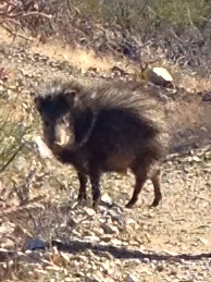
The dearth of flora on this hike abounds as there are innumerable species of cacti, desert shrubs  and trees along the trail. Although a "desert" landscape I was amazed by all of the plant life surrounding me in Saguaro NP.

I highly recommend planning your hike around sunset as the highest point of the hike provides an amazing panoramic view of the desert, mountains, Tucson and Saguaro cacti. From the highest point in the hike it is only 25 minutes to the trailhead so you can easily make it back to your car before it is too dark to see.


Saguaro National Park: West: Hugh Norris Trail

The longest trail in Saguaro National Park (west) starts from the Hohokam Trailhead 2.5 miles north of the Red Hills Visitor Center. If driving from Tucson I recommend taking Gates Pass Rd. through Tucson Mountain Park, over the pass of the Tucson Mountain Range, then following Kinney Rd. to the visitor center and trailhead.


This hike leads to Wasson Peak (4,687ft) the highest point in Saguaro NP (west). It is 4.9 miles each way and includes steep switchbacks and long sections along ridge lines completely exposed to the sun.


The hike begins with a series of switchbacks up to the ridge line  which you will then follow for the remainder of the hike. The trail is well-marked, maintained, and easy to follow throughout. I recommend going on this hike during the winter as during summer months the exposure to the sun would make it more difficult and less enjoyable. While ascending, you are afforded beautiful views of balanced rocks, Saguaro cacti, and swooping birds of prey.


As I turned a corner after a switchback I surprised a number of Javelinas (skunk pigs). They were startled and quickly made off away from me. It goes to show that even though the desert can appear quiet and empty you never know what might be around the corner!


Wasson Peak provided lovely panoramic views of the Sonoran Desert, the city of Tucson, and the Santa Catalina and Rincon Mountains to the east. This halfway point is a great spot for pictures and a relaxing lunch before heading back down the trail.


Friday, January 18, 2013

South Mountain (City of Phoenix Park)

South Mountain is large area so let me start by saying that I have only explored the western canyons and cannot speak to every area of the park.


The western canyons and trails were somewhat of a labyrinth with interconnecting trails, limited signs, and obvious off-trail damage done by humans carelessly trying to get from one canyon to another. All in all I encountered a number of people who were lost, frustrated, and unimpressed with the park.


South Mountain has a number of highly regarded trails that traverse 10+ miles over the mountains and connect this park to others in the Phoenix system. I also saw a lot of bikers and after walking the trails myself can see why. The wide trails and open terrain are much more biker than hiker friendly and I could see myself enjoying this parks sloping hills and lengthy ridges on a bike more so than my feet.


Despite the crowds and frustrating trail system I was able to find seclusion and beautiful overlooks from the ridge line. I would highly recommend spending the majority of any hike on the ridge line as opposed to the valley floor for better views, less dust, and easier ability to find your way.


Tuesday, January 15, 2013

Deem Hills Recreation Area (City of Phoenix Park)

This city park is both lovely and easy to access from the North Phoenix area. Trails can be accessed from the nearby Stetson Hills housing development or the nearby Deem Hills Park which contains an athletic field and playground. This city park had a community feel to it and offers both seclusion as well as a communal feel. 


The six mile trail around the circumference of the park was an easy and enjoyable walk little to no elevation change. The north side of the trail is secluded and offers outstanding views of the Sonoran Desert. The west and south sides of the trail offer lovely views of the housing communities to the north of Phoenix as well as the athletic fields and park which come up to the edge of the hills.


Saturday, January 12, 2013

Pinnacle Peak (City of Scottsdale Park)

Pinnacle Peak is a granite peak located in Scottsdale, AZ. It is surrounded by a housing development and contains a beautiful hiking trail as well as numerous sport and trad climbing options.


We started on Varicose, a 5.6 climb up a 70 ft crack in the granite wall. Definitely a great start to the day as this climb involved using one side of the body to work up the crack while the opposite side sought holds in the granite. No bolts on this route so make sure to bring all your trad gear.


We reached the summit from the South Crack, a 5.3 2 pitch 150 ft climb/scramble. Definitely a fun climb with lots of scrambling between large opening in between boulders. Again, no bolts on this one, all trad climbing!


Beautiful views of Scottsdale and Tonto National Forest from the summit.


And the best part, a 150 ft. rappel down from the top! Definitely a great day of climbing in beautiful winter weather. There are many other climbing options at Pinnacle Peak that I want to check out next time I am here.


Trusting the 'water knot' to rappel down from the summit of Pinnacle Peak.


Monday, January 7, 2013

Sandstone Peak (Santa Monica Mountains National Recreation Area)

The hike to Sandstone Peak, the highest in the Santa Monica Mountains, starts from the Sandstone Peak Trailhead off Yerba Buena Road and the Pacific Coast Highway. The trailhead has a nice-sized parking lot and new bathroom facilities. 


This six mile roundtrip trail is well-maintained, wide, and moderate until you reach the end. To gain the summit there is a short 20 ft. scramble over rock. This scramble is over easy to grip rock and is more fun than challenging.


Once at the top you have gorgeous views of Los Angeles and the Pacific Ocean. One of the best picture taking spots I have found in the Santa Monica Mountains. It does get quite windy at the top so we decided not to linger after we were done with pictures and had lunch after descending from the summit.  


Thursday, January 3, 2013

Zuma Canyon (Santa Monica Mountains National Recreation Area)

There are two trailheads for Zuma Canyon either off Busch Dr. or Bonsall Dr. depending on what hike you would like to do. Both are easily accessed off the Pacific Coast Highway and there are parking lots at both places. For this hike I decided to check out the Zuma Canyon Loop, Ocean View Trail, and Canyon View Trail. All of these trails are dog and family friendly.


After a steep ascent from the canyon floor to the ridge I was afforded excellent views deep into the canyon as well as over the Pacific Ocean. The number of trail options make this an excellent destination for any type of hiker as you can extend or shorten your trek depending on what you are looking for.


I did not see much wildlife on this hike but the serene atmosphere, views into the canyon, and of course the splendid Pacific Ocean made this a relaxing and refreshing afternoon hike.


Escondido Canyon and Falls (Santa Monica Mountains National Recreation Area)

This hike definitely has something for everyone. The parking lot is located directly off of the Pacific Coast Highway and from there it is a 1 mile walk up a paved road past some HUGE Malibu homes to the trailhead. Great people watching on the walk to the trailhead.


Once at the trailhead there is about a 2 mile walk through the canyon to the base of the falls. This walk is moderate over decently maintained trails and criss-crosses a creek several times. There were also several tree falls that needed to be navigated.


The base of the falls was much more impressive than I expected. Water dripped down from several overhanging tiers of rock and plant life into a clear pool at the bottom. There was no clear or obvious path to the top of the falls so I had to scout around the area to find the trail.  Loose rock to the right side of the falls appeared to be a path of least resistance that had been used before for the same purpose previously. Although a short climb distance wise it was challenging as I had to use my hands while scrambling over lose rock to gain the top. Do not attempt unless comfortable with heights and scrambling over loose rock.


Once at the top I was able to look down into clear pools of water that flowed over the precipice and form the falls. Previous hikers had taken time to carve their names into several trees at the top.


View from the side as water flowed off the top of the falls.


The view into the canyon floor with the Pacific Ocean in the background. A truly wonderful hike that surprised me with its beauty and the challenge of scrambling to the top of the falls. Definitely a hike I would return to and do again.